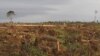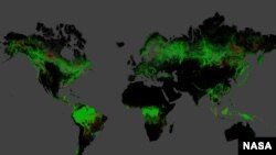
The world lost 2.3 million square kilometers of forest between 2000 and 2012 and gained 800,000 square kilometers according to a new study. The loss is more than 8 times the size of Texas, the biggest state in the continental U.S.
Deforestation, wildfires, windstorms and insects are all reasons for the decline as reported in a new study based on data from the NASA-U.S. Geological Survey Landsat 7 satellite. The researchers analyzed 143 billion pixels in 654,000 Landsat images to compile maps of forest loss and gain between 2000 and 2012.
The study was done by scientists from the University of Maryland, Google, the State University of New York, Woods Hole Research Center, the U.S. Geological Survey (USGS) and South Dakota State University.
During the study period, Brazil cut its deforestation rate from approximately 40,000 square kilometers per year to approximately 20,000 square kilometers per year.
"That's the result of a concerted policy effort to reduce deforestation, and it sets a standard for the rest of the world," said Matthew Hansen, whose team at the University of Maryland in College Park, Md., led the new study.
The team found that the deforestation rate in other countries increased. Indonesia's deforestation rate doubled in the study period, from approximately 10,000 square kilometers per year in 2000-2003 to more than 20,000 square kilometers in 2011-2012.
Prior to this study, country-to-country comparisons of forestry data were not possible at this level of accuracy. Different countries define forests differently, making previous global comparisons difficult with existing inventories.
"When you put together datasets that employ different methods and definitions, it's hard to synthesize," Hansen said. "But with Landsat, as a polar-orbiting instrument that takes the same quality pictures everywhere, we can apply the same algorithm to forests in the Amazon, in the Congo, in Indonesia, and so on. It's a huge improvement in our global monitoring capabilities."
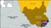
The maps also illustrate the impact of politics on land cover. On the island of Borneo, the maps clearly show the border between Malaysia and Indonesia. Malaysia's heavy logging along forest roads is visible right up to the Indonesian border, where forests were still largely intact as of 2012. In Côte d'Ivoire, a civil war in 2002 corresponded with intense deforestation of several previously protected nature reserves.
A different pattern of change appears in the southeastern U.S., where landowners harvest trees for timber and quickly plant their replacements.
"Of this eco-region in the southeast, 30 percent of the forest land was regrown or lost during this period," Hansen said. "It's incredibly intensive. Trees are really treated like a crop in this region."
In the U.S. state of Alabama, Landsat also detected miles-long streaks of destroyed forest. When the researchers examined the year-by-year record, they found the damage occurred in 2011 after a violent tornado season.
The results of the study will be published in the Nov. 15 issue of the journal Science.
You can have a look at the map details using this interactive tool.
Here's a video about the study:
Deforestation, wildfires, windstorms and insects are all reasons for the decline as reported in a new study based on data from the NASA-U.S. Geological Survey Landsat 7 satellite. The researchers analyzed 143 billion pixels in 654,000 Landsat images to compile maps of forest loss and gain between 2000 and 2012.
The study was done by scientists from the University of Maryland, Google, the State University of New York, Woods Hole Research Center, the U.S. Geological Survey (USGS) and South Dakota State University.
During the study period, Brazil cut its deforestation rate from approximately 40,000 square kilometers per year to approximately 20,000 square kilometers per year.
"That's the result of a concerted policy effort to reduce deforestation, and it sets a standard for the rest of the world," said Matthew Hansen, whose team at the University of Maryland in College Park, Md., led the new study.
The team found that the deforestation rate in other countries increased. Indonesia's deforestation rate doubled in the study period, from approximately 10,000 square kilometers per year in 2000-2003 to more than 20,000 square kilometers in 2011-2012.
Prior to this study, country-to-country comparisons of forestry data were not possible at this level of accuracy. Different countries define forests differently, making previous global comparisons difficult with existing inventories.
"When you put together datasets that employ different methods and definitions, it's hard to synthesize," Hansen said. "But with Landsat, as a polar-orbiting instrument that takes the same quality pictures everywhere, we can apply the same algorithm to forests in the Amazon, in the Congo, in Indonesia, and so on. It's a huge improvement in our global monitoring capabilities."
The maps also illustrate the impact of politics on land cover. On the island of Borneo, the maps clearly show the border between Malaysia and Indonesia. Malaysia's heavy logging along forest roads is visible right up to the Indonesian border, where forests were still largely intact as of 2012. In Côte d'Ivoire, a civil war in 2002 corresponded with intense deforestation of several previously protected nature reserves.
A different pattern of change appears in the southeastern U.S., where landowners harvest trees for timber and quickly plant their replacements.
"Of this eco-region in the southeast, 30 percent of the forest land was regrown or lost during this period," Hansen said. "It's incredibly intensive. Trees are really treated like a crop in this region."
In the U.S. state of Alabama, Landsat also detected miles-long streaks of destroyed forest. When the researchers examined the year-by-year record, they found the damage occurred in 2011 after a violent tornado season.
The results of the study will be published in the Nov. 15 issue of the journal Science.
You can have a look at the map details using this interactive tool.
Here's a video about the study: