Walking across London Bridge on a rainy, wet day in June 2011
Is Shrinking Arctic Ice to Blame For Britain's Wet Summers?
If you lived in or visited Great Britain and northwest Europe during the summers of 2007 through 2012 you probably remember how rainy they were.
Research just published by the science journal, “Environmental Research Letters” has added a new theory as a cause for the extraordinary soggy summers. The study found that a loss of Arctic sea ice is pushing the jet stream further south than normal, which in turn is causing an increase in summer rainfall throughout northwest Europe.
Using a computer model, Dr. James Screen from the University of Exeter said that he was able to examine just how European summer climate is impacted by the dramatic retreat of sea ice in the Arctic. Plugging in a variable that included the Arctic ice loss, Screen said that the predicted pattern of rainfall produced by his model was very close to the rainfall pattern of recent northwest European summers.
"The results of the computer model suggest that melting Arctic sea ice causes a change in the position of the jet stream and this could help to explain the recent wet summers we have seen,” said Screen. "The study suggests that loss of sea ice not only has an effect on the environment and wildlife of the Arctic region but has far reaching consequences for people living in Europe and beyond."
This shows the average location of the jet stream during wet summer months over northwest Europe.
According to the National Oceanic and Atmospheric Administration (NOAA), jet streams are narrow bands of strong wind, blowing usually 30 meters a second or more, located in the higher levels of the atmosphere. The northern and southern hemispheres have two powerful jet streams each. In the northern hemisphere it’s the polar jet stream which usually sits at roughly 60°N latitude and the subtropical jet stream that is at roughly at 30°N latitude. These jet streams are caused by the difference in temperature between tropical air masses and polar air masses and are responsible for guiding weather systems and their rain. The jet streams do vary in size and shape, usually with the change of seasons.
The jet stream impacts weather patterns for Britain and northwest Europe because in summer, it usually lies between Scotland and Iceland, causing the weather systems to pass north of Britain. However, when the jet stream pushes further south in the summer, it brings along with it an incredible amount of wet weather to Britain and northwest Europe.
While Screen’s weather model has suggested an increase in summer rainfall for northwest Europe, it also has predicted that the Mediterranean regions will receive less rain.
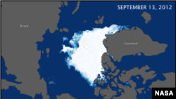
These maps compare the Arctic ice minimum extents from 2012 (top) and 1984 (bottom). In 1984 the minimum Arctic sea ice extent was 6.70 million square kilometers. The minimum ice extent in 2012 was nearly half of that at 3.41 million square kilometers.
There are, of course, a number of other factors along with the impact of melting Arctic sea ice that could also explain the recent run of wet summers.
Scientists have also been predicting a possible decade long cycle of wet summers in that part of the world due to a major warming in the North Atlantic Ocean in the 1990’s that has also had an effect on the jet stream.
To develop his findings, Screen compared the weather patterns that took place during these periods of low seasonal sea ice with the weather patterns that occurred during high seasonal sea ice conditions, such as those in the mid to late 1970’s.
Since his study didn’t use any estimates of how much sea ice there will be in the future, Screen said it could not predict future weather. The results, he says, do suggest however that if sea ice loss continues as it has over recent decades, the risk of wet summers may increase.
While earlier this year many weather prognosticators were predicting that the summer of 2013 would another wet and soggy one for the UK, it turned out that overall the summer was drier than the long-term average. Except for parts of north-west England and the Midlands area in central England, all areas had a drier than average summer. In fact, according to the Met Office, the UK's National Weather Service it was the driest summer for the UK since 2003 and for England the driest since 1996.
The NSIDC also recently reported that because of a cool and stormy summer, the seasonal Arctic sea ice melt in 2013 was less than when it set a record in 2012.