The U.S. Geological Survey reports that a magnitude 6.2 earthquake has hit a region in the eastern part of Indonesia.
The agency said the earthquake hit about 6:30 a.m. Friday in the Sumbawa region. The epicenter was about 30 kilometers south of Tolotangga.
The agency said the earthquake was about 72 kilometers deep.
There were no initial reports of injuries or damage.
On December 7, Indonesia's Aceh province was hit by a magnitude 6.5 quake that killed more than 100 people.
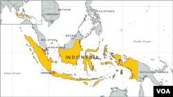
The world's largest archipelago, Indonesia is prone to earthquakes because of its location on the Pacific "Ring of Fire," an arc of volcanoes and fault lines in the Pacific Basin. A 2004 quake and tsunami killed a total of 230,000 people in a dozen countries, most of them in Aceh.