Online Watchdog Allows for Real-Time Forest Protection
Google Technology Powers Online Effort to Catch World's Forest Killers
A powerful new online forest monitoring system is the latest tool in the fight against deforestation.
The world's tree cover is disappearing at an alarming rate - 2.5 million square kilometers since 2000, the equivalent of 50 football [soccer] fields every minute of every day - because of fire, illegal logging and land gobbled up by farms, mining and oil operations. By the time these activities are discovered, it is often too late to do anything about them, much less determine who is at fault.
“It is possible to bring for the first time ever really, real-time data at a very local level to everybody in the world," he said. "And that is what Global Forest Watch is all about.”
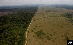
This Sept. 15, 2009 file photo shows a deforested area near Novo Progresso in Brazil's northern state of Para.Deforestation in the tropics is increasing by 2,000 square kilometers a year with half that loss in Brazil and Indonesia.
The program embeds key information into high resolution satellite images in a simple-to-use interactive website, says WRI’s Nigel Sizer, who heads the initiative.
“If you can use a Google map to find a friend’s house, then you can use Global Forest Watch to understand what is happening to forests in your community, across your country or even on the other side of the world and then take action,” Sizer said.
Mapping supply chains
Deforestation in the tropics is increasing by about 2,000 square kilometers a year according to WRI, with half that loss in Brazil and Indonesia.
Sizer says Global Forest Watch can help slow that down.
“It allows the government to focus their enforcement efforts in areas where illegal forest clearing is taking place," he said.
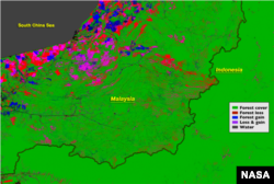
The border between Malaysia and Indonesia stands out in the Landsat-based map of forest disturbance. Red pixels represent forest loss between 2000 and 2012.
International companies like Nestles and Unilever have pledged not use raw materials for their products that contribute to deforestion.
"They are saying, 'We are going to use Global Forest Watch so that we know which of our suppliers are doing a good job and which ones are doing a bad job,'" Sizer said.
NASA has been collecting high-resolution satellite images of the earth since 1973, and when it made the archive public in 2008, it gave scientists the ability to assess changes in the Earth's landscape.
For Global Forest Watch, Google deployed the computing power of its Earth Engine technology to turn the latest 12 years of data into an interactive map, easily available to everyone everywhere. What would have taken a single computer 15 years, took Google just a couple of days.
“The science exists. The data exists, but the amount of data that is required, satellite image data, to actually have an accurate detailed current picture of the world’s forests; it is quadrillions of pixels," Moore said. "It is billions of megabytes of data. No one has ever been able to store, much less analyze, that data before.”
The satellite images are so detailed, it is possible to determine whether a section of forest has been logged, burned or felled by disease. Moore says users can take pictures of what happens on the ground and add to the database.
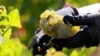
"You can follow the license plate on that truck with the illegal logs on the Trans Amazon Highway," she said. "That automatically can get uploaded into Global Forest Watch and support law enforcement."
Moore calls the potential of the combining the satellite images with the ground reality, all powered by the Internet, "unprecedented.”
Empowering indigenous people
No one hungers for this information more than Ecuadoran Juan Carlos Jintiach, who coordinates dialogue among native peoples and governments in nine Amazon basin countries. He says what they learn from Global Forest Watch will advance that conversation.
“It is a simple way to share our voice and histories," Jintiach said. "For the first time, using Global Forest Watch, we can easily upload alerts and photos for the entire world to see when encroachment happens in our forests and to monitor those lands in real time.”
Jintiach says the next step is to mobilize people to put the new tool to work to protect the world’s forests before it is too late.