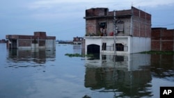
Every year India's northeastern state of Bihar is deluged by floods that submerge roads, destroy homes and wash away crops, leaving the disaster management authority struggling to monitor and assess the damage, and to distribute aid effectively.
But new satellite mapping of flood-prone areas should transform disaster response by equipping authorities with near real-time information about inundated villages, officials said.
Bihar, which borders the Himalayan nation of Nepal, is India's most flood-prone state. More than 70 percent of its total geographical area is at risk of annual floods, which put lives at risk and lead to heavy financial losses.
A major challenge for the Bihar state disaster management authority (BSDMA) has been mapping and monitoring flood-hit areas, according to the International Centre for Integrated Mountain Development (ICIMOD), which works to promote development across the Hindu Kush Himalayas.
Since floods started in the state last month, more than 200 people have died and more than 300,000 have been forced from their homes, disaster officials said.
ICOMOD has helped generate innovative flood mapping for 33 districts in Bihar and an online flood information system that is allowing faster response to a crisis, quicker damage assessment, and better risk management than with conventional methods, said officials from ICIMOD, based in Kathmandu.
"Traditionally, field teams are organized and dispatched to flooded areas to map floods. This can be time consuming and operationally difficult during a flooding event," Shahriar M. Wahid, a senior ICIMOD hydrologist, told the Thomson Reuters Foundation via email.
While "satellite-sourced flood maps alone cannot provide early warning to [the] at-risk population", he said, satellite data, in combination with flood simulations, can do this.
If flash floods triggered by torrential rain occur in Nepal, Bihar's residents can expect to see inundations about eight hours later, according to data from the BSDMA. Wahid said the new flood maps will be most useful for the distribution of relief, assessment of damages and to determine crop insurance payouts, among other benefits.
The project uses satellite technology that penetrates cloud cover, unlike optics-based satellite imagery. This is useful in the Himalayan region where monsoons bring thick clouds.
Flood maps can be generated within five to six hours after raw satellite data is received. The floods are circulated to government officials and relief agencies through a satellite communication network.
Space satellite technology is often touted by disaster relief experts as an important tool in managing the growing number of climate-linked disasters around the world.
But the cost of such technology for developing countries, even fast-growing ones like India, can be a challenge. ICIMOD is able to obtain some satellite data and images at no cost, which it then passes to the government for free, it said.
For many residents of Bihar's capital, Patna, prevention is the first step towards building resilience against floods that are increasing in intensity and frequency due to climate change.
Satellite maps can also aid prevention because they act as a template for years to come, recording rainfall patterns and data from the water department, among other factors, ICIMOD said.
"The very principles of urban planning in Bihar need a drastic review," said social worker Kumar Gaurav.
Planning "must now take into account global warming, intense and concentrated rainfall along with the construction boom that is responsible for high-rises on the Ganga's riverbed and floodplains," he said.
BHUBANESWAR, INDIA —