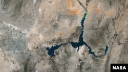
The 16-year drought in parts of the western United States has dropped the water level in the country's largest reservoir at Lake Mead to its lowest level in its 81-year history.
When full, the lake — straddling the Nevada-Arizona state border that was formed with the construction of the Hoover Dam during the Great Depression of the 1930s — has a surface elevation of more than 370 meters above sea level. It provides crucial water to the two states and also California, including Los Angeles, the country's second-biggest city.
But the Lake Mead level has been falling during the extended drought that has parched farmlands in the west and led to water rationing. In the last week, the recorded lake level fell to 327 meters above sea level.
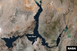
Lake Mead is currently at 37 percent of capacity and its shoreline has the distinctive look of a dirty bath tub, with rings marking where water levels once were.
Melting snowpacks that feed the lake from the Colorado River have diminished over the years. Emergency measures could be implemented if the water levels continue to fall throughout 2016, but the agency that manages the lake is predicting that its level could rise slightly in the coming months.