Iraq's Mosul Dam risks "catastrophic failure" and a massive wall of water that would sweep downstream anything in its path, including bodies, buildings, cars, unexploded ordnances and hazardous chemicals, the U.S. is warning.
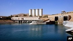
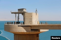
The dam, located on the Tigris River just north of Mosul, is the largest in the country. Built in 1984, the dam is structurally flawed and has required constant maintenance and shoring up with cement grout.

At full capacity, the dam can hold 11 cubic kilometers of water. If it were to burst at that level, a huge wave would roll down the river, potentially killing hundreds of thousands of people who are not able to move out of the way in time.
"The approximately 500,000 to 1.47 million Iraqis residing along the Tigris River in areas at highest risk from the projected floodway probably would not survive its impact," according to a statement released by the U.S. embassy in Baghdad.
Flood would reach Baghdad, devastate infrastructure
Flood waters could reach depths greater than 15 meters in some parts of Mosul city in as little as one to four hours, giving residents little time to flee.
In three to four days, the water would reach Baghdad, swelling the river that dissects the city by some 10 meters, and likely forcing the closure of the capital's international airport.
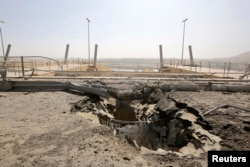
The 500-kilometer flood path would also damage or destroy large sections of infrastructure, and knock power plants offline, causing the entire Iraqi electricity grid to shut down. Farmland would also be severely damaged.
Mosul and the area down river are largely controlled by Islamic State militants, which could complicate any international relief effort, the U.S. embassy said.
After months of downplaying the seriousness of the risk, the Iraqi government recently acknowledged the need to strengthen the dam and contracted the Italian engineering firm Trevi to repair and maintain the structure.
NGOs and humanitarian agencies have already started work on contingency plans in case the dam bursts.
But it is unclear what would happen to the hundreds of thousands of vulnerable people already displaced by violence in Iraq.
Although it said had no specific information as to when the dam would collapse, the U.S. embassy said an early warning system and clear evacuation procedures could reduce the loss of life.
The U.S. embassy public warning comes after weeks of private notices calling on the international community and the government in Iraq to be prepared for such a disaster.