North America's tallest mountain doesn't just have a new name. It also has a new elevation.
Denali, the Alaska mountain formerly known as Mount McKinley, is now officially 3 meters (10 feet) shorter, measuring 6,190 meters (20,310 feet) at its highest point, the U.S. Geological Survey announced Wednesday.
The previous measurement of 6,193 meters (20,320 feet) stemmed from a 1953 survey that used the technology of the time, officials said. The new elevation is the result of data collected from the mountain by climbers in June using technology that didn't exist in the earlier survey, such as GPS instruments.
The climb to gather the data began June 15 and involved one climber from the University of Alaska Fairbanks and three climbers from the private survey company CompassData Inc., USGS spokesman Mark Newell said. During their 14 days on the mountain, the climbers pulled equipment and supplies on sleds.
The change comes just days after the Obama administration announced its decision to bestow the traditional Alaska Native name to the mountain on the eve of president's visit to Alaska this week. The change to Denali - an Athabascan word meaning “the high one” - replaces the name that honored the 25th president, William McKinley, who never set foot in Alaska.
“We think this revised elevation, with a more precise measurement, is a fitting tribute to the name Denali,” Newell said.
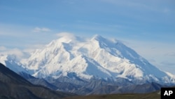
Known for its majestic views, the mountain is dotted with glaciers and covered at the top with snow year-round. Powerful winds make it difficult for the adventurous few who seek to climb it. Each year, about 1,200 climbers attempt to summit the mountain, with only about half actually succeeding.
Using GPS instruments for the latest measurement provided more defined elevations than technology that was used in 2013 to calculate a slightly lower elevation. The 2013 calculation put the mountain at 6,170 meters (20,237 feet), but it was carried out with aerial radar measurements that fall short in pinpointing exact elevations, Newell said.
The raw data collected in June was analyzed and processed to determine the new elevation. Officials said researchers had to take certain factors into account, including the depth of the snowpack at the summit.