Large areas of Texas and Oklahoma are struggling to recover from flooding brought on by heavy rains that swept over the southern plains Monday and into Tuesday morning.
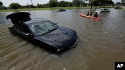
Some of the most heavily traveled roads to the north and south of downtown Houston turned into rivers of dark, muddy water during the torrential downpours. Dozens of automobiles and trucks were abandoned along some highways, and water flowed into the ground floors of houses and some business buildings in low-lying areas.
With more rain expected, Houston Mayor Annise Parker said city workers would be going into affected areas as soon as possible to see what could be done.
“Those areas that are under water would be the ones that we are most concerned about, but public works will be out as soon as it is safe to do so to inspect overpasses and bridges,” Parker said.
The mayor said that while more rain is expected through this week, forecasters do not expect anything nearly as big as Monday’s storm. While critical roadways were cut off by the floodwaters, Parker noted that most parts of the city came through the big storm well.
“Much of Houston was unaffected by last night’s torrential rains or today’s flooding, and the bayous have begun to recede," she said. "We have to remember that we are the point of a really big funnel that kind of extends up into central Texas, and a lot of water flows through Houston. It is still a dangerous situation along the bayous; they are full of water and the water is moving very rapidly.”
One thing that helped authorities respond quickly to this storm is a sophisticated early warning system designed in 1997 by Rice University civil engineering professor Phil Bedient.
“It has run really well over the years, but this was a real challenge because of the size of the event,” he said.
Bedient said the Flood Alert System 3, or FAS3, uses radar, hydrological modeling and data from a variety of sources to give an 80 to 90 percent accurate prediction of rainfall in the area around the Texas Medical Center, where some hospitals were flooded during hurricanes in past years.
Bedient said the massive storm system that rolled over central and east Texas on Monday and Tuesday put the FAS3 to a real test.
“This system that came through yesterday and also the system that hit central Texas as well, in Wimberley and San Marcos, these systems were kind of linked together and they created just enormous intensities of rainfall," he said. "You know, we had a river over there that rose 30 feet [about 9 meters] in less than one hour, which is just unheard of.”
Bedient said the warning system is now being used by police and emergency response agencies, but that he would like to see devices in each emergency vehicle. The FAS3 is updated every five minutes and can be accessed from any computer with an Internet connection.
He said well-informed citizens are able to protect themselves from flood-related tragedies. “All they needed in some of these river systems was one or two hours for people to get to high ground so that they don’t get killed or they don’t lose their vehicles," Bedient said.
This has been one of the rainiest seasons on record in Texas. There have been very few weeks in recent months when it did not rain in the Houston area, and the drought that plagued much of central Texas over the past several years has now been halted in most areas as reservoirs fill up and rivers flow at normal or above-normal levels.