European Satellite Breaks Up, Burns on Return to Earth
Kru pesawat TNI AU C-130 Squadron 31 menggunakan teropong untuk menelusuri cakrawala dalam operasi pencarian pesawat AirAsia 8501 yang hilang di atas perairan Selat Karimata di Indonesia, 29 Desember 2014.
A European satellite that ran out of fuel re-entered the Earth's atmosphere early Monday, with some pieces falling harmlessly into the sea.
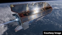
The European Space Agency’s Gravity field and steady-state Ocean Circulation Explorer satellite surrendered to the laws of gravity, dropped from its orbit and fell toward Earth.
The ESA's Space Debris Office said the satellite, known as GOCE, reentered Earth’s atmosphere over the southern Atlantic Ocean, near the Falkland Islands. The spacecraft began its descent to Earth during a final orbital pass that took it over Siberia, the western Pacific Ocean, the eastern Indian Ocean and Antarctica.
All but about 25 percent of the 1,100-kilogram spacecraft disintegrated in the high atmosphere. ESA said any remaining remnants of GOCE fell harmlessly into the southern Atlantic Ocean. No injuries or property damage have been reported as a result of the spacecraft’s return to Earth.
ESA said the GOCE mission came to an end in the middle of October when it ran out of its xenon fuel and began dropping from its orbit at a height of about 224 kilometers above Earth.
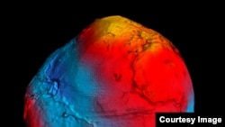
Following its launch on March 17, 2009, from the Plesetsk Cosmodrome in Russia, the GOCE was able to precisely map variations in Earth’s gravity.
As a result of its mapping efforts, ESA scientists said that they were able to create the most accurate shape of the ‘geoid’ that had ever been produced.
The ‘geoid’ is the shape the surface of the oceans would have if only influenced by the gravity and rotation of the Earth, and without the effects of other common factors such as winds and tides.
With this map, scientists will be able to better understand ocean circulation, sea level, ice dynamics and the Earth’s interior.
The GOCE also provided the data that allowed for the creation of the first global high-resolution map of the ‘Mohorovicic Discontinuity’ or Moho, which is the boundary between Earth’s crust and mantle.
Among its other accomplishments, the low orbiting GOCE also detected sound waves from the massive earthquake that hit Japan on March 11, 2011.
The GOCE spacecraft with its sleek, aerodynamic design and unique electrically powered ion propulsion engine was also referred to as the ‘Ferrari of space.’
The Voice of America provides news and information in more than 40 languages to an estimated weekly audience of over 326 million people. Stories with the VOA News byline are the work of multiple VOA journalists and may contain information from wire service reports.