BANGKOK —
The next phase in the search for a missing Malaysia Airlines passenger jet, believed to be at the bottom of the Indian Ocean, is likely to test the limits of existing technology.
Australian officials say they are consulting with counterparts in China, Malaysia and the United States before deciding on what direction to take next in the search for Malaysia Airlines Flight 370, missing since March 8.
Australia’s prime minister Tony Abbott says a new search strategy will be needed if a U.S. Navy robotic submarine is unable to locate any trace of the 63-meter long jetliner on the seabed floor. Abbot told reporters Wednesday that the search will not be abandoned “until we have done everything we can to solve this mystery.”
Australia’s defense minister, David Johnston, says an announcement is expected next week and it is likely to involve “more capable” side-scan sonar devices.
Ron Allum, an Australian who designs vehicles for deep sea exploration, tells VOA such technology as described by the defense minister has a proven track record.
“That’s a vehicle that was used to find the wrecks of Titanic, Bismarck and HMS Sydney," Allum explained. "I thought that would have been probably brought into play earlier.”
Allum has dived in a submarine to a depth of 5,000 meters to help film the wreck of the Bismarck, a German battleship sunk by the British in the North Atlantic in 1941.
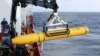
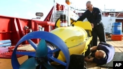
The U.S. Navy’s Bluefin-21 submersible has combed nearly all of a 310-square-kilometer search area on the bed of the Indian Ocean, off Australia’s west coast, near where signals believed to be from the plane’s black box were previously detected. So far, there has been no indication that its three-dimensional sonar map of the ocean floor has revealed anything relevant.
Much of the seabed where the submersible has been deployed is uncharted and as deep as seven kilometers.
Allum says existing equipment’s maximum operating depth is around six kilometers.
“A towed device is going to be really at the limit of the cable, as well," he noted, "because if you lower a steel cable into the deepest part of the ocean it will break under its own weight. So the cable length can become an issue.”
But Allum says looking for the plane’s fuselage at that depth would be easier with a towed device than relying on the remotely operated robot submersible vehicles.
“With a towed side scan you’ve got immediate feedback, it’s not limited by batteries," Allum explained. "It doesn’t have to come back to the surface to be downloaded. It can operate 24/7 behind a ship.”
An air search involving 10 planes was suspended for a second consecutive day Wednesday due to poor visibility and rough seas below.
However a dozen ships continued to search an area covering 38,000 square kilometers. No verified debris or oil from the plane has been spotted since it veered off course on March 8. Photographs of an unidentified two-and-a-half meter long metallic object which washed ashore 10 kilometers east of Augusta in western Australia are being analyzed by specialists.
The Malaysia Airlines flight, from Kuala Lumpur to Beijing, was carrying 239 passengers and crew. An unprecedented analysis of routine engine diagnostic signals from the Boeing 777 jet to satellites led searchers to a remote section of ocean far off the airliner’s scheduled course.
Australian officials say they are consulting with counterparts in China, Malaysia and the United States before deciding on what direction to take next in the search for Malaysia Airlines Flight 370, missing since March 8.
Australia’s prime minister Tony Abbott says a new search strategy will be needed if a U.S. Navy robotic submarine is unable to locate any trace of the 63-meter long jetliner on the seabed floor. Abbot told reporters Wednesday that the search will not be abandoned “until we have done everything we can to solve this mystery.”
Australia’s defense minister, David Johnston, says an announcement is expected next week and it is likely to involve “more capable” side-scan sonar devices.
Ron Allum, an Australian who designs vehicles for deep sea exploration, tells VOA such technology as described by the defense minister has a proven track record.
“That’s a vehicle that was used to find the wrecks of Titanic, Bismarck and HMS Sydney," Allum explained. "I thought that would have been probably brought into play earlier.”
Allum has dived in a submarine to a depth of 5,000 meters to help film the wreck of the Bismarck, a German battleship sunk by the British in the North Atlantic in 1941.
The U.S. Navy’s Bluefin-21 submersible has combed nearly all of a 310-square-kilometer search area on the bed of the Indian Ocean, off Australia’s west coast, near where signals believed to be from the plane’s black box were previously detected. So far, there has been no indication that its three-dimensional sonar map of the ocean floor has revealed anything relevant.
Much of the seabed where the submersible has been deployed is uncharted and as deep as seven kilometers.
Allum says existing equipment’s maximum operating depth is around six kilometers.
“A towed device is going to be really at the limit of the cable, as well," he noted, "because if you lower a steel cable into the deepest part of the ocean it will break under its own weight. So the cable length can become an issue.”
But Allum says looking for the plane’s fuselage at that depth would be easier with a towed device than relying on the remotely operated robot submersible vehicles.
“With a towed side scan you’ve got immediate feedback, it’s not limited by batteries," Allum explained. "It doesn’t have to come back to the surface to be downloaded. It can operate 24/7 behind a ship.”
An air search involving 10 planes was suspended for a second consecutive day Wednesday due to poor visibility and rough seas below.
However a dozen ships continued to search an area covering 38,000 square kilometers. No verified debris or oil from the plane has been spotted since it veered off course on March 8. Photographs of an unidentified two-and-a-half meter long metallic object which washed ashore 10 kilometers east of Augusta in western Australia are being analyzed by specialists.
The Malaysia Airlines flight, from Kuala Lumpur to Beijing, was carrying 239 passengers and crew. An unprecedented analysis of routine engine diagnostic signals from the Boeing 777 jet to satellites led searchers to a remote section of ocean far off the airliner’s scheduled course.