JAKARTA - Virtual mapping has become a vital tool in forest conservation, allowing the public to see where deforestation is occurring. In Indonesia, several environmental organizations are leading efforts with new technology that they hope will pressure businesses and the government to stop illegal logging.
When the environmental news website Mongabay launched its Indonesia site in late May it revealed a new tool that will allow users to monitor changes in Indonesia’s forest cover.
Mongabay founder Rhett Butler worked with the U.S. National Aeronautics and Space Administration to develop the platform, which uses satellite remote sensing images to track forest loss every quarter.
"The key to really going after deforestation is first of all understanding where it’s happening, and so once you have that information then you can take some sort of action," Butler explained.
Butler says non-governmental organizations (NGOs) can use the deforestation alert tool to enter areas where trees are being cut, determine why that is happening and then work with local communities to stop deforestation.
The government could also use the tool to determine if companies operating in deforested areas have the proper licenses.
Indonesia has the world’s third largest tropical rainforest after Brazil and the Democratic Republic of Congo. It also has some of the most diverse plant and animal life on the planet. But in the past two decades more than 24 million hectares of forest have been cleared. Much of that clearing has been done to make way for palm oil plantations.
Officials have recently committed to conserving forests and reducing greenhouse gases that are released when trees are cut in swampy areas with carbon-rich peat. Forest and peatland destruction accounts for 80 percent of Indonesia’s annual carbon emissions, which President Susilo Bambang Yudhoyono has pledged to reduce by 26 percent by 2020.
That means Indonesia could some day look like Brazil, which has seen dramatic reductions in deforestation since it made reducing forest loss a priority starting in 2004.
But Butler says much of that progress depends on pressure from the private sector.
"Governments tend not to lead. Leadership tends to come from the private sector and civil society, so the government may have a plan, but there is no guarantee that it will be implemented," he said.
Indonesia has struggled to conserve its forests while also maintaining high economic growth. Much of its economy depends on the sale of timber and other forest-based products, like palm oil.
The government issues land-use permits to determine which areas should be preserved and which can be developed. But Kuntoro Mangkusubroto, chair of the REDD+ Task Force, which helps coordinate activities aimed at reducing emissions from deforestation, says the problem is in creating one uniform map for issuing land-use permits.
Meanwhile, environmental groups are developing mapping systems like the forest cover analyzer, a tool soon to be launched by the World Resource Institute, a global environmental think tank, to track the forest losses.
Rauf Prasodjo, a research analyst helping develop the tool, explains how it works.
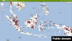
"This map here of Kalimantan shows the annual tree cover loss from the year 2001 to 2010. What you can do with this map, is you can do it per annually, it’s the purple dots there," Prasodjo explained. "Then you can see per year where deforestation has occurred."
A smattering of purple dots light up Prasodjo’s screen when he selects 2001. When he requests the change in forest cover over the last nine years the dots turn to blotches, like giant ink stains.
Prasodjo says the tool could help potential investors seeking certification for palm oil projects from the Roundtable on Sustainable Palm Oil, an industry group promoting environmentally friendly palm oil development. They could enter the coordinates of their concession and determine vital information, such as the total amount of primary forest in the area.
As the tools improve, they make it easier to determine what lies within the forests. And Prasodjo says that makes companies a lot more accountable for their actions.
"You’re in conferences and you just hear ‘we’re not cutting down forests' or 'We have been more careful in conducting that.’ I think tools is just a nice proof of saying this is what my argument is based on and, if it is publicly available and people can see what’s happening based on satellite images, I think that people will understand more what’s happening on the field," Prasodjo said.
Other groups are using Google Maps technology and helping develop other tools to give even more detailed pictures of Indonesia’s vast forests - including revealing not only where deforestation occurs, but also the species of plants on the ground.
When the environmental news website Mongabay launched its Indonesia site in late May it revealed a new tool that will allow users to monitor changes in Indonesia’s forest cover.
Mongabay founder Rhett Butler worked with the U.S. National Aeronautics and Space Administration to develop the platform, which uses satellite remote sensing images to track forest loss every quarter.
"The key to really going after deforestation is first of all understanding where it’s happening, and so once you have that information then you can take some sort of action," Butler explained.
Butler says non-governmental organizations (NGOs) can use the deforestation alert tool to enter areas where trees are being cut, determine why that is happening and then work with local communities to stop deforestation.
The government could also use the tool to determine if companies operating in deforested areas have the proper licenses.
Indonesia has the world’s third largest tropical rainforest after Brazil and the Democratic Republic of Congo. It also has some of the most diverse plant and animal life on the planet. But in the past two decades more than 24 million hectares of forest have been cleared. Much of that clearing has been done to make way for palm oil plantations.
Officials have recently committed to conserving forests and reducing greenhouse gases that are released when trees are cut in swampy areas with carbon-rich peat. Forest and peatland destruction accounts for 80 percent of Indonesia’s annual carbon emissions, which President Susilo Bambang Yudhoyono has pledged to reduce by 26 percent by 2020.
That means Indonesia could some day look like Brazil, which has seen dramatic reductions in deforestation since it made reducing forest loss a priority starting in 2004.
But Butler says much of that progress depends on pressure from the private sector.
"Governments tend not to lead. Leadership tends to come from the private sector and civil society, so the government may have a plan, but there is no guarantee that it will be implemented," he said.
Indonesia has struggled to conserve its forests while also maintaining high economic growth. Much of its economy depends on the sale of timber and other forest-based products, like palm oil.
The government issues land-use permits to determine which areas should be preserved and which can be developed. But Kuntoro Mangkusubroto, chair of the REDD+ Task Force, which helps coordinate activities aimed at reducing emissions from deforestation, says the problem is in creating one uniform map for issuing land-use permits.
Meanwhile, environmental groups are developing mapping systems like the forest cover analyzer, a tool soon to be launched by the World Resource Institute, a global environmental think tank, to track the forest losses.
Rauf Prasodjo, a research analyst helping develop the tool, explains how it works.
"This map here of Kalimantan shows the annual tree cover loss from the year 2001 to 2010. What you can do with this map, is you can do it per annually, it’s the purple dots there," Prasodjo explained. "Then you can see per year where deforestation has occurred."
A smattering of purple dots light up Prasodjo’s screen when he selects 2001. When he requests the change in forest cover over the last nine years the dots turn to blotches, like giant ink stains.
Prasodjo says the tool could help potential investors seeking certification for palm oil projects from the Roundtable on Sustainable Palm Oil, an industry group promoting environmentally friendly palm oil development. They could enter the coordinates of their concession and determine vital information, such as the total amount of primary forest in the area.
As the tools improve, they make it easier to determine what lies within the forests. And Prasodjo says that makes companies a lot more accountable for their actions.
"You’re in conferences and you just hear ‘we’re not cutting down forests' or 'We have been more careful in conducting that.’ I think tools is just a nice proof of saying this is what my argument is based on and, if it is publicly available and people can see what’s happening based on satellite images, I think that people will understand more what’s happening on the field," Prasodjo said.
Other groups are using Google Maps technology and helping develop other tools to give even more detailed pictures of Indonesia’s vast forests - including revealing not only where deforestation occurs, but also the species of plants on the ground.