A powerful earthquake has struck eastern Indonesia, but there have been no early reports of damage and no tsunami warning was issued.
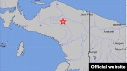
The The U.S. Geological Survey says the quake struck Papua province on Saturday at 4:42 a.m. ((13:42 UTC). The agency put the depth of the 7.2 magnitude quake at 68 kilometers. It was centered 239 kilometers east of the city of Enarotali.
Officials say hundreds of people in the area ran into the streets, fearing building collapses and aftershocks.
Indonesia sits on the Pacific "Ring of Fire," where continental plates collide, causing frequent seismic and volcanic activity.
Some information for this report was provided by AP and AFP.