For the second time this week, new satellite images have been released for Sudan’s Southern Kordofan State, where Sudanese armed forces have been fighting the rebel SPLA-North Sector.
The Satellite Sentinel Project (SSP) said Friday’s images indicate an apparent artillery barrage and an attempt to block civilians from crossing the border into South Sudan.
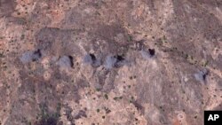
“The latest images are probably some of the most visually striking we have captured so far at Satellite Sentinel,” said Nathaniel Raymond, head of the Harvard Humanitarian Initiative, which analyzes the satellite images.
Smoke Plumes
“One of the lead images,” he said, “is six plumes of grey smoke consistent with an artillery barrage on a ridge in the area known as Toroge. And that area, according to information we received last night from sources on the ground, has been the site of fighting for the past two days or so.”
Images indicate Sudanese forces are at battalion strength on the Buram-Jau Road. It’s been the main route civilians had been taking to South Sudan to escape the fighting. The road leads to the Yida refugee camp in South Sudan.
Earlier this week, the SSP released images showing a build-up of Sudanese forces in Southern Kordofan, along with road construction. It said the information indicated a pending military offensive against the Nuba people in the Kauda Valley.
“It does not show the beginning of the offensive that we fear will take place in the next few weeks,” said Raymond. But he added that the position of the Sudanese troops has created a “choke point” on the Buram-Jau Road, which is about 45 kilometers north of the Yida camp.
“The position is described as a choke point because it sits directly across the road and in a mountainous area where there is basically one way down that stretch to get to the border with South Sudan. And now we know why there has been a decreasing flow of civilians across that border,” he said.
Accusations and denial
The Sudan Armed Forces have accused the Satellite Sentinel Project of helping the SPLA-North rebels by providing them with information.
“My reaction to that accusation is simply this – The Satellite Sentinel Project and the analytic operation that we run at the Harvard Humanitarian Initiative is party to the Red Cross NGO code of conduct, which means that we are impartial. We do not provide information to either side. What we do provide information about is specific to one thing: threats against civilians,” Raymond said.
He said the SSP does not provide GPS coordinates.
“We do show specific information, yes, when it’s relevant about the Sudan Armed Forces’ bases and positions. But that’s when those bases and positions are threats to civilians,” he said.
A spokesman for Sudanese forces, Col. Al-Sawarmi Khalid Said, is quoted as saying the SSP is “carrying out a hostile operation” and that the armed forces are responsible for protecting civilians.
Raymond rejected those comments. He said, “South Kordofan and the Blue Nile have been the site of clear evidence of mass atrocities against the civilian populations there. We have documented evidence of systematic house to house mass killing in Kadugli, the displacement of the entirety of the Dinka-Not population from Abyei, the bombing and burning and armored attacks on civilian villages in Blue Nile and the displacement of hundreds of thousands of civilians,” he said.
He added, “If the Sudan Armed Forces is responsible for civilian protection, then it is no surprise why so many civilians have fled.”
The SSP has called on the international community to “take responsibility for civilian protection.”