At Columbia University’s Lamont-Doherty Earth Observatory, a short drive north of New York City, more than 300 scientists and researchers are delving into the geophysical mysteries of our planet from virtually every angle.
One project is to discover what’s happening beneath the world’s largest ice sheet in remote eastern Antarctica.
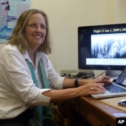
It’s late afternoon at the Lamont-Doherty Earth Observatory, where Robin Bell is at work analyzing various images of glaciers and plotting her next expedition to the frozen southern pole. She takes a break to explain why she loves ice so much.
“Ice is cool because it is really hard to look under. So there are all kinds of mysteries that are underneath the ice sheet that you can’t see without sending out radar energy. You get to look somewhere nobody has looked before. So you get to find things that nobody had thought about before.”

Hidden wonder
Such as an entire mountain range, hidden from view beneath a sheet of ice several kilometers thick.
“We went to the middle of the Eastern Antarctica ice sheet, which the biggest one on the planet. It covers the entire eastern half of Antarctica. The top of the ice sheet is about 4,200 meters high (above sea level) and underneath that is a mountain range. The Russians discovered the mountain range when they drove across it in 1958, and they found the ice was really thin there. But nobody had been back there, pretty much, in the following 50 years.”
There is no visible evidence of these peaks and valleys beneath the unbroken surface of the ice field, and Bell was determined to learn more about them.
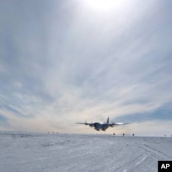
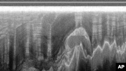
In 2008, she outfitted a small plane with sensitive laser, radar and magnetic-field monitoring equipment, and oversaw a series of systematic aerial surveys over the ice sheet. The resulting images, which look very much like dental X-rays, showed the mountains, and more.
Closer look
“There were things that looked more like clouds or mushrooms or something at the bottom of the ice sheet. But big! Like a kilometer thick. So, being a scientist, first you think there is something wrong with your instruments, because there shouldn’t be things that look like this under the ice sheet. But when you start seeing it on one line and then five kilometers later you see it on the next line and then the next one you begin to think ‘there might actually be something there.’”
What Bell was seeing was an entire range of mountains, more like the Alps than the scattered “mega-bumps” she and her team expected to find. There were also valleys and, at the base of the mountains, four kilometers underground, rivers of slow-moving water.
“When we go to the middle of Antarctica, the average temperature is roughly minus-40 degrees Centigrade (Celsius). That’s at the surface. But the ice sheet acts like a blanket and captures the heat of the earth coming up. So the bottom of the ice sheet is only about minus two degrees Centigrade. So it’s not very far from melting. It’s pretty warm down there.”
Bell and her team found other surprises in this hidden, ice-blanketed world, such as rivers that flowed uphill.
“We really hadn’t thought about what would happen to water and valleys when you drop a four and a half kilometer thick ice sheet on top of it and that you’d actually end up driving the water up the hill. Because the ice is thinner at the end of the valley than down at the bottom. So the water is actually getting squirted uphill.”
Revamping impressions
The discovery that liquid water is flowing beneath Antarctica’s massive ice sheet has forced scientists to revise their view of the so-called “frozen continent.” It was long believed that the ice sheet was layered like a birthday cake, with the newest ice near the top, where the most recent snowfalls had frozen.
But Bell says it now seems that some of the most ancient ice is being melted and then pressed uphill by the weight of the ice above it, until it freezes again. That means many ice layers higher up in the ice sheet might actually be more ancient than the layers below them.
“Which is a kind of a backwards way of thinking about things.”
Bell says her research might seem exotic but its implications are urgent.
“If we want to know how the ice sheets are going to change in the future, we need to know how they are going to move. And they move on their bottoms. So what the bottom of the ice sheet is made of really matters.”
Bell believes her work at Columbia University’s Lamont-Doherty Earth Observatory is doing more than deepening our understanding of the physics of polar ice.
Bell says that knowing why and how that ice melts will also help scientists better predict the effects of global climate change, and the profound environmental impacts it is certain to have.