Hurricane Irene has strengthened as it bears down on the Bahamas on a path toward the eastern United States.
The National Hurricane Center said in its latest bulletin Wednesday that Irene's sustained winds are nearly 185 kilometers an hour, making it a Category Three storm on a five-point scale. The center says Irene could become a Category Four hurricane by Thursday.
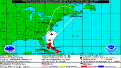
The storm's center is forecast to move across the southeastern and central Bahamas Wednesday, and over the northwestern Bahamas on Thursday.
The hurricane center's director, Bill Read, says tropical storm force winds could approach the U.S. state of North Carolina as soon as early Saturday morning. Evacuations were already under way in parts of the state.
Read says the storm could become a "big threat" on Sunday to the northeast United States, including New York's Long Island.
Irene is the first hurricane to seriously threaten the United States in three years. The Federal Emergency Management Agency (FEMA) says that emergency personnel are preparing all along the coast.
At last report, forecasters said the storm was about 460 kilometers southeast of Nassau, Bahamas, moving northwest at 19 kilometers per hour.
The storm lashed the British territory of the Turks and Caicos Islands Tuesday.
Authorities say Irene could cause flooding in the U.S. mid-Atlantic and New England regions, where soil is saturated from recent heavy rains. They say Irene's tropical storm-force winds extend 335 kilometers from the center.
The U.S. State Department has warned Americans to carefully consider the risk of traveling to the Bahamas and Turks and Caicos due to the hurricane.
Some information for this report was provided by AP, AFP and Reuters.
A Video Visualization of Hurricane Irene from NOAA