The climate phenomenon known as El Niño looks to be on its way back, forecasters say, raising the odds of droughts in some places and floods in others.
There are early signs that this could develop into the biggest one on record.
But experts say they cannot know for sure yet, and local impacts are even harder to predict.
Global impacts
El Niño occurs every few years, when tropical waters off the Pacific coast of South America turn warmer than normal. Warm air rises off those waters and changes the path of the major wind currents that blow around the planet.
It can weaken monsoons in South and Southeast Asia. Rainy seasons in southern Africa can turn dry. Meanwhile, east Africa and South America can get soaked.
The latest official forecasts give about two-thirds odds that El Niño will develop by the end of the year.
Under the surface
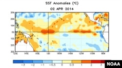
But what has really attracted attention is the huge body of warm water building up below the surface of the tropical Pacific.
Meteorologists say there is more energy stored up underwater now than at this point in 1997, just before the strongest El Niño on record developed.
The 1997-98 El Niño led to catastrophic floods in Peru, forest fires in Indonesia and Malaysia and record-high global temperatures.
If those warm waters in the eastern Pacific make their way to the surface and stay there, it could mean a major El Niño event, weather havoc worldwide and possibly new high-temperature records.
No guarantee
However, “just having a lot of warm water below the surface now is not enough to guarantee that we’re going to have a strong El Niño,” notes Tony Barnston, chief forecaster Tony Barnston at Columbia University’s International Research Institute for Climate and Society.
The warm water could dissipate. It could come to the surface but not linger. Barnston says El Niño is notoriously difficult to predict at this time of year.
Plus, the atmosphere has been in a cooler cycle for the past several years, which many say does not favor a strong El Niño.
And, finally, a note of caution from Gary Eilerts, who manages the Famine Early Warning System Network for the U.S. Agency for International Development. Eilerts was in Africa for the 1997-98 El Niño.
“We said this is going to be a big one,” he said. “This could be the mother of all impacts on food insecurity in southern Africa.”
The rains came late, but when they came, “we had almost a normal season,” Eilerts added. “And that was in the face of the largest El Niño ever recorded.”
Future predictions
Forecasters should have a better picture of what El Niño has in store by August.
What the more distant future holds in a changing climate is even less clear.
“El Niño goes back hundreds of thousands of years, so clearly, El Niño is not related to climate change,” said Mike Halpert, head of the Climate Prediction Center at the National Oceanic and Atmospheric Administration. “Now, the question is, does climate change have an impact? And that’s still an open question.”
There are early signs that this could develop into the biggest one on record.
But experts say they cannot know for sure yet, and local impacts are even harder to predict.
Global impacts
El Niño occurs every few years, when tropical waters off the Pacific coast of South America turn warmer than normal. Warm air rises off those waters and changes the path of the major wind currents that blow around the planet.
It can weaken monsoons in South and Southeast Asia. Rainy seasons in southern Africa can turn dry. Meanwhile, east Africa and South America can get soaked.
The latest official forecasts give about two-thirds odds that El Niño will develop by the end of the year.
Under the surface
But what has really attracted attention is the huge body of warm water building up below the surface of the tropical Pacific.
Meteorologists say there is more energy stored up underwater now than at this point in 1997, just before the strongest El Niño on record developed.
The 1997-98 El Niño led to catastrophic floods in Peru, forest fires in Indonesia and Malaysia and record-high global temperatures.
If those warm waters in the eastern Pacific make their way to the surface and stay there, it could mean a major El Niño event, weather havoc worldwide and possibly new high-temperature records.
No guarantee
However, “just having a lot of warm water below the surface now is not enough to guarantee that we’re going to have a strong El Niño,” notes Tony Barnston, chief forecaster Tony Barnston at Columbia University’s International Research Institute for Climate and Society.
The warm water could dissipate. It could come to the surface but not linger. Barnston says El Niño is notoriously difficult to predict at this time of year.
Plus, the atmosphere has been in a cooler cycle for the past several years, which many say does not favor a strong El Niño.
And, finally, a note of caution from Gary Eilerts, who manages the Famine Early Warning System Network for the U.S. Agency for International Development. Eilerts was in Africa for the 1997-98 El Niño.
“We said this is going to be a big one,” he said. “This could be the mother of all impacts on food insecurity in southern Africa.”
The rains came late, but when they came, “we had almost a normal season,” Eilerts added. “And that was in the face of the largest El Niño ever recorded.”
Future predictions
Forecasters should have a better picture of what El Niño has in store by August.
What the more distant future holds in a changing climate is even less clear.
“El Niño goes back hundreds of thousands of years, so clearly, El Niño is not related to climate change,” said Mike Halpert, head of the Climate Prediction Center at the National Oceanic and Atmospheric Administration. “Now, the question is, does climate change have an impact? And that’s still an open question.”