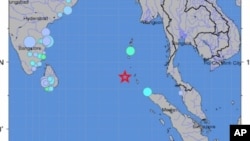
A strong earthquake of 7.7 magnitude has struck near India's Nicobar Islands, triggering a tsunami watch for all areas of the Indian Ocean.
The U.S. Pacific Tsunami Warning Center says quakes of this size have the potential to generate a destructive local or regional tsunami.
A watch in effect for India, Indonesia, Sri Lanka, Burma, Thailand and Malaysia.
The U.S. Geological Survey says the quake struck at 1926 UTC Saturday, or
1:26 Sunday morning local time at the epicenter. The epicenter was 150 kilometers west of Mohean on the Nicobar Islands at a depth of 35 kilometers.
The Nicobar islands are a chain of small islands across the Andaman Sea from southern Thailand.
In December 2004, a magnitude 9.0 quake off the coast of Sumatra triggered an Indian Ocean tsunami that killed nearly 230,000 people.
Most of the casualties were in Indonesia's Aceh province, but the tsunami wrecked coastal communities over a large part of the Indian Ocean basin.
Some information for this report provided by AP and AFP.
Major 7.7 Quake Hits Near India's Nicobar Islands


