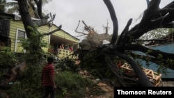
Tropical Depression Fred is producing heavy rains over eastern Cuba and might regain its tropical storm status Friday as it heads toward Florida, setting off a storm warning from the National Hurricane Center for the Florida Keys west of Ocean Reef to the Dry Tortugas.
The hurricane center’s midday update puts Fred ahead of its anticipated course as it moves with maximum sustained winds of 55 kph (34 mph). The center previously said Fred was expected to experience “slow strengthening” over the next few days but now predicts that “tropical storm conditions are expected somewhere within the [Florida] warning area within 36 hours.”
Fred is expected to move along or just north of eastern and central Cuba through Friday night, forecasters say, and be near the Florida Keys and southern Florida on Saturday. Fred is predicted to be near the west coast of Florida on Sunday.
Through Monday, 7.5 to 18 centimeters (3-7 inches) of rain is anticipated across the Keys, the southern and central Florida Peninsula, and north along the western coast of Florida, with isolated maximum totals of 25 centimeters (10 inches). The hurricane center said the rainfall could lead to urban and small-stream flooding, and potentially lead to isolated moderate river flooding.
Keys officials said there are no evacuation plans in place for tourists or residents of Monroe County, according to the Associated Press.
Fred has resulted in tropical storm watches for several areas: the Cuban provinces of Ciego de Avila, Camaguey, Las Tunas, Holguin and Granma; and the southwest coast of Florida from Bonita Beach south and east to Ocean Reef including Florida Bay.
Fred is expected to produce 2.5 to 7.5 centimeters (1-3 inches) of rain over Cuba and the eastern Bahamas, the NHC said, while bringing as much as 12.5 centimeters (5 inches) in some locations. In the western Bahamas, Fred is predicted to dump 7.5 to 12.5 centimeters (3-5 inches), with isolated maximum totals of 20.5 centimeters (8 inches).
Forecasters are also tracking another potential tropical storm in the Atlantic and have issued tropical storm watches for the islands of Antigua and Barbuda, St. Kitts and Nevis, and Montserrat. The weather disturbance would be named Grace and become the seventh named storm in the Atlantic hurricane season if it strengthens into a tropical storm.
The U.S. Virgin Islands and Puerto Rico were instructed to monitor the system’s progress, and the center said those regions will likely receive tropical storm watches by Friday night.