New satellite images indicate that the Sudan Armed Forces (SAF) are upgrading air bases recently captured from rebels. The Satellite Sentinel Project said the bases are located along the Blue Nile State border with South Sudan.
“The Sudan Armed Forces are lengthening and upgrading runways in Kurmuk and ad-Damazin,” said Nathaniel Raymond, head of the Harvard Humanitarian Initiative, which analyzes the satellite images. The images also show four additional helipads being constructed in Kurmuk.
“Why this is significant is that in the past 72 hours there have been credible reports of attacks by the Sudan Armed Forces across the border into South Sudan, including Upper Nile [State], hitting refugee camps; and the new facilities that they appear to be putting in ad-Damazin and Kurmuk would only increase the capacity to do those types of attacks,” he said.
Rapid build-up
The images show the airbase upgrades occurred quickly.
“In the case of the helipads in Kurmuk, approximately seven days,” he said.
There is also evidence the Kurmuk perimeter has been fortified and the presence of armored vehicles. Images also show “burning” at the end of the airstrip, but it’s unclear whether this means a further lengthening of the runway or just a result of wildfires.
“In the case of ad-Damazin, within approximately a month after the capture of that airstrip by the Sudan Armed Forces, they were in the process of lengthening the runway by 250 meters,” he said.
Satellite images throughout the year have shown a build-up of Sudan Armed Forces along the border with South Sudan. Sudan has been battling rebels in Southern Kordofan and Blue Nile States. The Satellite Sentinel Project has accused Sudan of causing many civilian casualties in the process.
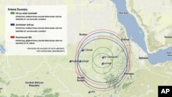
“The main conclusion that I think is important for the long term view of the situation between north and South Sudan is expressed by a simple graphic map we included in our recent report. What that map shows is a series of concentric circles radiating out from ad-Damazin and Kurmuk. These circles are the ranges of aircraft that we know have been used in the past for indiscriminate bombing campaigns by the SAF in Southern Kordofan and Blue Nile and Abyei. The point is that now they can use those same planes about a hundred miles deeper into South Sudanese territory,” he said.
A return to war?
On Wednesday, the U.S. State Department condemned a Sudanese airstrike in Guffa in Upper Nile State that reportedly killed seven people at a refugee camp. It called the attack provocative and warned if could increase the chance of war between the north and south.
A second aerial attack was reported on Thursday around a refugee camp in Yida in South Sudan’s Unity State.
A long civil war between the north and south officially ended in 2005 with the signing of the Comprehensive Peace Agreement (CPA). South Sudan became an independent nation this past July.
“The past week and a half has, I think, firmly shown that it would be naive to not consider the potential for a return to war given the statements by both presidents. That said, however, from a Satellite Sentinel Project perspective, we are continuing to collect data. The limit of what we know now if that they’re enhancing their capacity to engage in more frequent, closer range air operations across the border,” said Raymond.
He said the United States and the rest of the international community must send a message to both sides to either stop attacks or show restraint and that they offer inducements for both sides to stand down.
“Because the situation could spiral out of control very quickly,” he said.