
Indigenous peoples whose land rights have often been exploited due to lack of maps and data have a new tool to help secure their rights: a global interactive map of the land they claim called LandMark.
Indigenous peoples and communities claim to hold about two-thirds of the world's land but are legally recognized as holding only 10 percent, according to think thank World Resources Institute (WRI), one of the organizations behind the project.
"By visualizing the locations of indigenous peoples and local communities-involving perhaps 2 billion people-LandMark pushes their existence into the calculations of those making decisions about climate change, economic development, poverty alleviation, and natural resources conservation," Peter Veit, director of the WRI's Land and Resources Rights initiative, said in a statement.
"LandMark provides indigenous peoples and communities the opportunity to be proactive in their efforts to protect their lands, not just reactive to imminent threats."
Without legal rights to land, indigenous communities may find their land is taken over for the exploitative development of natural resources, palm oil plantations and logging, according to the WRI.
Mapping their territory gives them an opportunity to show that their land is not vacant, idle or available for outsiders, it said.
According to WRI ensuring rainforest communities have secure land rights could reduce deforestation and land-use conflicts and prevent tens of millions of tons of carbon dioxide emissions each year.
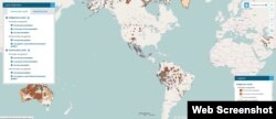
Developed by a partnership of indigenous groups and land rights and research bodies, the beta version of the map launched on Nov. 10 shows the boundaries of thousands of pieces of land claimed by indigenous people and communities around the world.
It offers additional information about the lands such as land category and area.
Still in the development stage, the map is not a "crowd-sourcing" platform but aims to provide only high-quality data available from recognized organizations and experts who can submit their entries directly through www.LandMarkMap.org.