The Indonesian island of Lombok Sudnay suffered its third major quake in a month.
The magnitude 6.3 quake jolted the island, causing landslides on Mount Rinjani and damaging buildings as the island tries to recover from a magnitude 6.9 quake earlier this month that killed 460 people, damaged tens of thousands of homes and displaced several hundred thousand people.
The island suffered a magnitude 6.4 quake on July 28.
There have been no reports of injuries or deaths so far from the latest tremor.
Sunday's quake was felt on the neighboring island of Bali and was preceded by few minutes by a magnitude 5.4 quake, also in Lombok’s northeast.
The U.S. Geological Survey said Indonesia’s Sunday quake, which was centered in the northeast of the island, struck at a depth of 7 kilometers (4 miles).
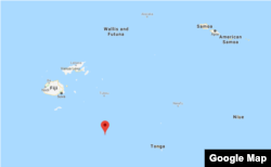
Hours earlier a magnitude 8.2 earthquake struck in the Pacific Ocean close to Fiji and Tonga. While the quake was a much greater magnitude, it occurred very deep, 347.7 miles (559.57 km) down, the U.S. Geological Survey and U.S. Tsunami Warning Center said. That depth would have dampened the shaking at the surface.
“I would not expect any damage. People will feel it, but it’s so deep that I would not expect any damage,” USGS geophysicist Jana Pursley said by telephone.
The U.S. Tsunami Warning Center said the quake was too deep to cause a tsunami, however later reports indicated a small tsunami was observed.
The epicenter was 167 miles (270 km) east of Levuka in Fiji and 275 miles (443 km) west of Neiafu in Tonga.
The quake was initially reported as a magnitude 8.0 and then upgraded to 8.2, a magnitude that could cause tremendous damage had it not been so deep.
The area is located on the earthquake-prone Ring of Fire.