As flood waters invade fields and homes along the Mississippi River in the states of Tennessee, Arkansas and Mississippi, officials farther south, in the state of Louisiana are preparing for the worst. Louisiana's governor is urging citizens to take action now.
The U.S. Army Corps of Engineers is still studying a proposal to open floodgates at the Morganza spillway in an effort to protect the cities of Baton Rouge and New Orleans farther downstream. But opening the floodgates would inundate farm fields, forest lands and some residences in the area.
Louisiana Governor Bobby Jindal is asking people in the potential flood zone to start preparing now instead of waiting for a final decision by the Corps of Engineers.
“Act as if the Corps is going to open the spillway. The best thing to do is to be prepared as if that decision is coming. I do not want people waiting; I do not want them to hesitate about whether they need to make evacuation plans or move their valuables or build these levees,” he said.
The Morganza spillway is about 75 kilometers upriver from the Louisiana capital of Baton Rouge. Last week, the U.S. Corps of Engineers blew up a section of a levee in Missouri to protect river towns in Kentucky and Illinois, but flooding 52,000 hectares of farmland as a result.
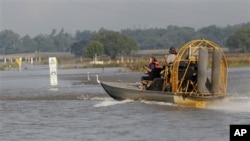
Monday, the Corps opened the Bonne Carre spillway near New Orleans for the first time since 2008. But the level of the Mississippi River is setting records upriver in places like Vicksburg and Natchez, Mississippi, where low-lying residential areas are being flooded.
But experts say the situation would have been far worse if it had not been for the levees, spillways and other controls that have been built along the river since the devastating flood of 1927 that killed more than 1,000 people and flooded large areas of the south, especially in Louisiana.
The other concern for officials monitoring the river crest is the presence of 11 oil refineries along the lower Mississippi that process about two and a half million barrels a day and supply about 13 percent of the gasoline used by motorists in the United States.
At least two of those refineries could be shut down temporarily by flooding. Experts say if the shutdowns are short, a week or two, the effect will be moderate, but if they are shut down for many weeks there could be a prolonged rise in fuel prices. U.S. motorists are already complaining about gasoline prices, now at the highest level since the oil price spike of 2008.
The flooding along the Mississippi and its tributaries is considered the worst in 80 years. The cause of the flooding is snow melt and heavy rains in the northern part of the United States. Meantime, southern plains states like Texas and Oklahoma are experiencing severe drought and high winds that have caused raging wildfires. There has also been a record number of tornadoes along a path from Texas to Georgia that have killed more than 200 people in six states this year.
Mississippi River Floods Threaten Homes, Farms, Refineries in Louisiana
- By Greg Flakus