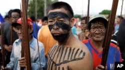
Indigenous groups in Paraguay, battling to protect their ancestral lands from expanding agriculture and cattle ranching, launched the first online map of their territory Tuesday.
Paraguay's beef and soy export industries are the main drivers of deforestation in the fast-growing South American nation, often coming into conflict with some 120,000 indigenous people, according to the World Resources Institute (WRI), a think tank.
The online platform and map, Tierras Indigenas, was built by Paraguay's Federation for the Self-Determination of Indigenous Peoples (FAPI), and so far 13 of the country's 19 indigenous peoples have contributed to it, Washington-based WRI said.
The communities, who largely rely on the water, food, medicine and shelter from forests to survive, hope the map will help businesses and government to work out whether their activities are on legally recognized indigenous lands.
"Private companies and banks, for example, will now be able to use this tool to assess land ownership and rights prior to conducting business in these areas," said WRI, which provided technical support to create the map.
A growing number of indigenous groups around the world are using data, drones and apps to formally map their lands, forests and water sources to better monitor and protect them.
Tierras Indigenas allows users to see where an indigenous group has legally recognized land, its size, the number of families living there, and if a forest is in a protected area.
WRI hopes the geographic data can help to avoid conflict over land rights and tenure, and reduce deforestation through monitoring and timely alerts.
"[The map] makes it less likely these lands will be dispossessed and converted into export-oriented commodity agriculture," Ryan Sarsfield, an expert on supply chain risk in Latin America with WRI, told Reuters. "The next step is to ensure that these maps are visible and available publicly so they can be used in decision-making processes in which indigenous people have often been excluded."


