MANILA —
Torrential rains that caused major flooding in the northern Philippines last month tested the country’s brand new weather monitoring system. Project NOAH, the Nationwide Operational Assessment of Hazards, is a technology-based system intended to ascertain when and where natural disasters strike.
Philippine Geologist Carlos Primo David says the phrase “weather whether” has become the common joke for forecasting in the Philippines. “Weather and whether, w-h-e-t-h-e-r, whether it comes or not. That’s what it means. So if it rains, then it rains. That’s essentially what the phrase means," he explained. "But, we refuse to believe that we cannot predict rainfall.”
David and his team of physicists are part of a group of scientists and meteorologists that is working on the government’s Project NOAH. The idea is to change the prevailing “weather whether” attitude in this archipelago, which is susceptible to heavy rains with deadly floods, earthquakes, tsunamis and volcanic eruptions.
At the end of 2011, more than 1,200 people died in the southern part of the country because of major floods brought on by a tropical storm. This prompted President Benigno Aquino to order the country’s Science and Technology Department to come up with a more accurate prediction of natural disasters and an integrated response. Project NOAH came together with the help of the scientists who had already started research in the respective components.
Project NOAH Executive Director Mahar Lagmay says high-resolution surveying of the entire country is essential to the $40 million project.
“To be able to construct hazard maps you need very high resolution topography. To do the simulations of floods you do need high-resolution topography,” he said.
University of the Philippines geology professor Lagmay says these will be used to create smaller area maps, which will be crucial to how people respond to natural disasters.
“By doing local scale, or community scale maps, people can relate with the problem because they see their houses, they see their neighbor’s houses," he added. "The bridge in their community, the river in their community in relation to the hazards - the flood hazards in particular."
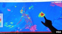
Project NOAH is accessible on the Internet and all components are expected to be completed in 2014. They include a flood information network, landslide susceptibility and storm surge warnings among others. Right now anyone can look up a forecast at the NOAH website by plugging in a location and picking rainfall prediction with a look at cloud patterns or stream heights, among other combinations.
Geologist Carlos Primo David’s team at the University of the Philippines in Manila is working toward flood prediction. But first they are fine-tuning rain prediction to help determine where flooding will happen. David says the team relies on satellites, Doppler radar and hundreds of rain gauges all stationed across the country.
“And, so our forecasts are specific. Rainfall, 95 percent chance of rainfall in Makati- specific to the area. And, 20 percent chance of rainfall, small amount of chance in Laguna. Then I have something to use, to plan,” David stated.
David says the data also predicts the intensity of the rainfall within an hour.
During the heavy rains in August, the capital region, Manila, experienced roof-high flooding. The state weather bureau used NOAH’s rainfall information and re-broadcast its automated alerts on the social networking site, Twitter. And, a corresponding color code warning system was put in place and read by radio and television announcers.
Lagmay says the project passed its first test because government used the data to carry out evacuations. “Relatively it was successful because what we wanted to avoid was mass death,” he said.
But, so far the project is still not widely known.
After a quick check of more than a dozen people on the streets of Manila’s business district, almost none of them had ever heard of Project NOAH.
One woman in line at a bus stop said she was “a little familiar” with it. Janice Lagundi says it determines the most probable locations where flooding can happen. But she said adding the color code to already existing weather warnings would take some getting used to.
“We might associate those colors for the strength of the wind, for the strength of the rain, but who knows… so it’s really confusing,” she added.
Project NOAH’s executive director, Mahar Lagmay, says the government’s challenge now is to get people to change their mindset from not doing anything about weather events that appear to be random to actively preparing for the worst.
Philippine Geologist Carlos Primo David says the phrase “weather whether” has become the common joke for forecasting in the Philippines. “Weather and whether, w-h-e-t-h-e-r, whether it comes or not. That’s what it means. So if it rains, then it rains. That’s essentially what the phrase means," he explained. "But, we refuse to believe that we cannot predict rainfall.”
David and his team of physicists are part of a group of scientists and meteorologists that is working on the government’s Project NOAH. The idea is to change the prevailing “weather whether” attitude in this archipelago, which is susceptible to heavy rains with deadly floods, earthquakes, tsunamis and volcanic eruptions.
At the end of 2011, more than 1,200 people died in the southern part of the country because of major floods brought on by a tropical storm. This prompted President Benigno Aquino to order the country’s Science and Technology Department to come up with a more accurate prediction of natural disasters and an integrated response. Project NOAH came together with the help of the scientists who had already started research in the respective components.
Project NOAH Executive Director Mahar Lagmay says high-resolution surveying of the entire country is essential to the $40 million project.
“To be able to construct hazard maps you need very high resolution topography. To do the simulations of floods you do need high-resolution topography,” he said.
University of the Philippines geology professor Lagmay says these will be used to create smaller area maps, which will be crucial to how people respond to natural disasters.
“By doing local scale, or community scale maps, people can relate with the problem because they see their houses, they see their neighbor’s houses," he added. "The bridge in their community, the river in their community in relation to the hazards - the flood hazards in particular."
Project NOAH is accessible on the Internet and all components are expected to be completed in 2014. They include a flood information network, landslide susceptibility and storm surge warnings among others. Right now anyone can look up a forecast at the NOAH website by plugging in a location and picking rainfall prediction with a look at cloud patterns or stream heights, among other combinations.
Geologist Carlos Primo David’s team at the University of the Philippines in Manila is working toward flood prediction. But first they are fine-tuning rain prediction to help determine where flooding will happen. David says the team relies on satellites, Doppler radar and hundreds of rain gauges all stationed across the country.
“And, so our forecasts are specific. Rainfall, 95 percent chance of rainfall in Makati- specific to the area. And, 20 percent chance of rainfall, small amount of chance in Laguna. Then I have something to use, to plan,” David stated.
David says the data also predicts the intensity of the rainfall within an hour.
During the heavy rains in August, the capital region, Manila, experienced roof-high flooding. The state weather bureau used NOAH’s rainfall information and re-broadcast its automated alerts on the social networking site, Twitter. And, a corresponding color code warning system was put in place and read by radio and television announcers.
Lagmay says the project passed its first test because government used the data to carry out evacuations. “Relatively it was successful because what we wanted to avoid was mass death,” he said.
But, so far the project is still not widely known.
After a quick check of more than a dozen people on the streets of Manila’s business district, almost none of them had ever heard of Project NOAH.
One woman in line at a bus stop said she was “a little familiar” with it. Janice Lagundi says it determines the most probable locations where flooding can happen. But she said adding the color code to already existing weather warnings would take some getting used to.
“We might associate those colors for the strength of the wind, for the strength of the rain, but who knows… so it’s really confusing,” she added.
Project NOAH’s executive director, Mahar Lagmay, says the government’s challenge now is to get people to change their mindset from not doing anything about weather events that appear to be random to actively preparing for the worst.