In India, proposed legislation to ban use of maps or satellite images of the country without approval from the government has led to an outcry and triggered an online campaign called “Save The Map.”
The controversy is not just over stiff penalties of up to $15 million for a wrong depiction of India’s borders, but that in a digital era, the law would potentially disrupt a host of businesses and start-ups such as taxi-hailing services.
Reasons
The draft Geospatial Information Regulation Bill seeks to regulate the use of mapping and satellite data for two reasons: secure the country’s strategic installations from enemies and terrorists and ensure that its political boundaries are correctly depicted. The government says it will not create barriers to business.
But Internet experts say the sweeping proposed law will affect ordinary people using mobiles and laptops, all new-age companies such as food-delivery and e-commerce, apps, as well as Apple and Google map products.
Nikhil Pahwa, founder of the website MediaNama, calls location data the core fabric of all digital services.
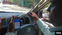
“What the government has ended up doing is making pretty much every single app illegal because they all use geospatial data and they wont have a license. If you take a photograph, it has location data. If you use Uber to hail a cab, it uses maps and it shows taxi cabs on the map. If I WhatsApp my location to a friend to pick me from a particular location, I am generating geospatial information,” he said.
Complications for ordinary citizens
The draft law requires anyone wanting to use, publish or own maps or geospatial data to apply for a license, which will be considered by a security vetting committee.
The Bangalore-based Center for Internet and Society (CIS) has also slammed the new bill, saying it takes India back more than three decades when businesses were governed by a maze of bureaucratic licenses and permits.
“What it does, it puts in place a license raj for all use of mapping technologies. That just does not make sense. No other country in the world has this regressive mapping law,” said Pranesh Prakash at CIS.
Internet opposition
A volunteer-led internet campaign called “Save The Map” led by Bangalore-based tech experts, is steadily gathering momentum. It is calling on people to petition the government against the bill in its present form. It seeks to replicate an extremely successful campaign called “SavetheInternet” which built public opinion and put pressure on the government to ensure equal access to the internet.
The government has sought to calm the growing concerns, saying the bill is only in a preliminary stage and it has invited feedback and suggestions from the public untill June 4 .
Officials point to India’s growing security concerns, specially since an armed attack at a strategic air base in Pathankot in northern India earlier this year, allegedly mounted by Pakistan-based terrorists. Speaking to an Indian newspaper, Junior Home Minister Kiren Rijiju said the bill is necessary because “India as a responsible country must have provisions to secure its boundary and territory.
However Prakash of CIS points out that the new bill will not necessarily prevent terror groups from getting hold of geospatial data to target Indian installations because they don’t need maps generated inside India to access such information.
“They need satellite imagery and they need maps, period. Now this law does not actually prevent such maps from being created, it does not prevent satellite images of India being captured. What it does is prevent Indians from doing so. So it won't prevent foreign-based terrorists, especially state-backed terrorists, from attacking India,” he said.
Internet and public policy experts agree that the government could impose restrictions on mapping and satellite images of strategic and sensitive locations in the country.
Huge fines
The eye-popping fines of up to $15 million and jail terms of up to seven years proposed for incorrect depiction of India’s borders have also caused surprise.
India has always insisted maps should show Kashmir in the north, which is claimed by both India and Pakistan and the state of Arunachal Pradesh in the northeast, which China claims, within Indian political boundaries.
Foreign magazines and newspapers which failed to do so were only allowed to circulate in the country after the words “Boundaries of India shown in this map are not correct” were stamped over maps that did not conform to India’s interpretations of its borders.
Google already offers slightly altered versions of its maps inside India, showing the disputed regions of Kashmir and Arunachal Pradesh as part of India.
Independent political analyst Ajoy Bose said New Delhi has long been very sensitive over how these two territories are depicted. “It has always been a source of annoyance to successive governments, but this government being ultranationalist in nature is very particular about India’s geographical boundaries being correctly shown, and therefore it is taking much more drastic action,” he said.