NEW YORK —
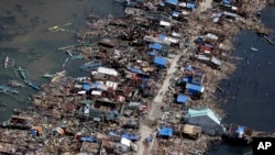
Weather experts say that Typhoon Haiyan, which struck the Philippines on Friday and is expected to hit the Southeast Asian mainland by Sunday, may turn out to be the most powerful such storm since modern record-keeping began. That has some people wondering if it may be the beginning of a period of more intense and dangerous weather, brought about by climate change.
Radley Horton, a climate scientist at Columbia University’s Earth Institute in New York, said it is difficult to blame any one storm - even one as powerful as Typhoon Haiyan - on climate change.
“… But what we can say is that as the climate changes, we’re going to see more of certain types extreme events; our vulnerability is going to go up because of that. As greenhouse gases, such as carbon dioxide, have increased in the atmosphere due to our burning of fossil fuels and land use changes - that’s warming the atmosphere. Some of that heat has gotten into the oceans, has caused the oceans to expand and it causes some of the ice that’s on land to make its way to the ocean. Both of those processes are causing sea levels to rise,” said Horton.
High seas combined with a typhoon’s powerful winds can create sea surges, which can flood low-lying islands and coastal areas. Warmer seas also can contribute, though, to the force of a typhoon weather system itself.
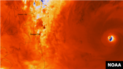
The Suomi NPP satellite captured an incredibly detailed infrared image of Super Typhoon Haiyan's eye as it orbited over the storm at approximately 05:25 UTC on Nov. 7, 2013. (Photo: NASA/NOAA)
Adam Sobel, an atmosphere scientist at Columbia’s Lamont-Doherty Earth Observatory, likens the mechanism that drives a typhoon to the gasoline-powered engine that propels an automobile.
“Your car makes mechanical energy from heat, which it gets by burning fuel. In the case of a typhoon, the heat comes from the warm tropical ocean and it moves up into upper atmosphere, which is cold. And the power that the storm can generate is related to the difference between that warm ocean and the cold upper atmosphere. And as the climate warms, the tropical ocean gets warmer and the upper atmosphere where the cyclone moves heat up to is, if anything, getting colder," he said.
Sobel said the frequency of typhoons will not necessarily increase with warmer oceans. "But what we do think will happen is that the typhoons we have will get stronger. And so the chance of getting a really powerful one like Haiyan, which is extremely powerful, is reasonably likely to increase.”
Horton added that there are other elements that might determine the possible strength of future typhoons. “What are the wind patterns going to be like in the atmosphere? What is the temperature profile going to be like in the atmosphere? What's going to happen with the dust in the atmosphere?”
One conclusion Horton, Sobel and most of their fellow climate scientists share: if humans don’t slow the rate of greenhouse gas emissions, there is a risk seas will rise so much that many coastal areas will be swamped, forcing millions of people to migrate.