The massive underwater volcanic eruption in Tonga was so powerful it was recorded around the world and triggered a tsunami that flooded Pacific coastlines from Japan to the United States, scientists said Sunday.
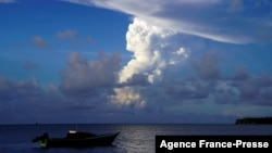
Dramatic satellite images showed the long, rumbling eruption of the Hunga Tonga-Hunga Ha'apai volcano spew smoke and ash into the air, with a thunderous roar recorded 10,000 kilometers (6,000 miles) away in Alaska.
The U.S. Geological Survey recorded Saturday's eruption as equivalent to a 5.8 magnitude earthquake at zero depth.
New Zealand scientist Marco Brenna, a senior lecturer at Otago University's School of Geology, described the impact of the eruption as "relatively mild" but said another eruption with a much bigger impact could not be ruled out.
Waves of around 1.2 meters hit along Japan's Pacific coast with the Japan Meteorological Agency warning waves as high as three meters were possible.
In New Zealand, more than 2,300 kilometers from Tonga, 120 people were evacuated from northern coastal areas and several boats destroyed when a huge wave crashed into a marina.
Australia's popular Bondi Beach in Sydney was briefly evacuated as a precaution while in California, coastal streets in Santa Cruz were awash and closed to traffic.
The National Weather Service Alaska reported the Alaska Volcano Observatory had recorded the eruption in Anchorage and Fairbanks "6,000 miles from the volcano."
The Fife weather station in Scotland tweeted it was "just incredible to think of the power that can send a shockwave around the world" after the eruptions produced a jump in its air pressure graph.
Hunga-Tonga-Hunga-Ha'apai, which lies about 65 kilometers north of Nuku'alofa, has a history of volatility.
In recent years, it breached sea level during a 2009 eruption while in 2015 it spewed so many large rocks and ash into the air that when they settled a new island had formed 2 kilometers long by 1 kilometer wide and 100 meters high.