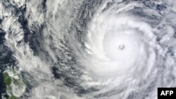
The most powerful storm on the planet so far this year, Super Typhoon Vongfong, is churning in the Pacific and is forecast to strike mainland Japan before Monday.
Weather forecasters are keeping a close watch on the storm since Super Typhoon Haiyan devastated the Philippines last year, killing 6,000 people.
Satellite images of Vongfong have revealed a perfectly formed eye, 40 kilometers in size, surrounded by a giant swirling disc of cloud, northeast of the Philippines.
US Air Force monitoring storm
Among those in Japan monitoring the typhoon is U.S. Air Force weather flight chief Master Sergeant Tonya Trythall, of the 18th Operations Support Squadron at Kadena Air Base on the island of Okinawa.
She said the storm’s current location is one of the better places to sustain a tropical cyclone, above warm water and ideal upper-level winds.
“But as it starts turning north, not only does the water start cooling off slightly, especially this time of year, but you’re starting to get some stronger upper level winds that will start to try to tear the storm apart," Trythall said. "The storm itself is going to be stronger so it’s not going to tear it apart easily but it does weaken it."
The slowly-moving storm is believed to have already reached peak intensity with winds in excess of 330 kilometers per hours. Over open water, far from land, Vongfong yet poses little danger except to any boats unlucky to have ventured too near where ocean waves are as high as 15 meters.
The typhoon will bear down on Okinawa on Saturday -- where it is predicted to dump up to 48 centimeters of rain -- before continuing north toward the southern and central islands of mainland Japan.
Trythall said it is still a guess as to where, precisely, Vongfong will come ashore on the Japanese main islands.
“Since we don’t have the hurricane reconnaissance flights in the Pacific, there’s a little bit more uncertainty to the track. The influence of other weather systems coming off of the mainland will make a big difference in the final track,” Trythall added.
Vongong is not the only powerful storm currently in Asian waters.
Cyclone Hudhud
Meteorologists say tropical cyclone Hudhud has intensified as it crossed the Andaman and Nicobar islands and is likely to be packing 140 kph winds when it slams into India's east coast Sunday.
Last year, a more powerful cyclone, Phailin, made landfall in the same area, battering the state of Odisha.
Media reports from the state on Thursday described scenes of panic buying, sending prices of essential food items up 50 percent, ahead of expected evacuations of coastal villages.


