Hurricane Lane strengthened to a Category 4 storm Tuesday as it looks poised to impact Hawaii later this week.
The National Weather Service has issued a hurricane watch for the island of Hawaii and Maui County, which includes the island of Maui and several smaller islands.
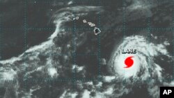
Lane's wind speeds increased to nearly 250 kilometers per hour (155 mph) as it moved west. It is expected to turn toward Hawaii on Wednesday.
It is not clear if the storm will directly strike the islands or just graze them, but authorities warned of heavy rains, flash flooding and strong winds.
Officials were urging residents to use Tuesday and Wednesday to prepare.
Late Tuesday, the storm was located about 644 kilometers (400 miles) south-southeast of Hilo on the island of Hawaii, known as the Big Island.
Hurricane Lane "is forecast to move dangerously close to the main Hawaiian islands as a hurricane later this week, potentially bringing damaging winds and life-threatening flash flooding from heavy rainfall,'' the weather service's Central Pacific Hurricane Center warned.